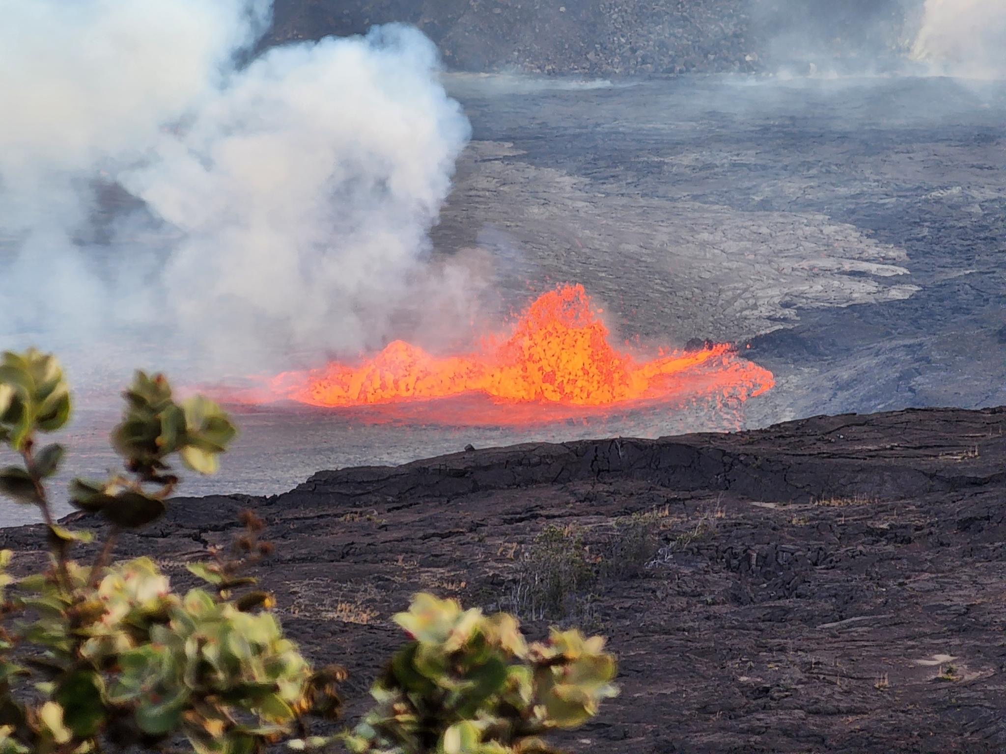
Hiking the Puʻu ʻŌʻō Trail: Kīlauea's Epic Eruption Site
Trek across a surreal landscape of hardened lava on the Puʻu ʻŌʻō Trail. This challenging hike offers a direct encounter with the powerful legacy of Kīlauea's historic 35-year eruption.
For 35 years, the Puʻu ʻŌʻō vent on Kīlauea's East Rift Zone was a relentless source of creation and destruction, its lava flows constantly reshaping the landscape of Hawaiʻi Island. Today, that eruption is quiet, but its legacy is etched into the earth. Hiking the Puʻu ʻŌʻō Trail is not just a walk; it's a journey across one of the youngest landscapes on the planet, a stark and beautiful testament to volcanic power.
This isn't a casual stroll to a viewpoint. It's a rugged trek over a sea of hardened pāhoehoe and aʻā lava, guided only by stone markers. For those prepared for the challenge, it offers an unparalleled experience in the heart of Hawaiʻi Volcanoes National Park.
The History of Puʻu ʻŌʻō: A 35-Year Eruption
To appreciate the trail, you must first understand the vent that gives it its name. The Puʻu ʻŌʻō eruption began on January 3, 1983. For the next three and a half decades, it was the longest and most voluminous eruption of Kīlauea's past 200 years. According to the U.S. Geological Survey (USGS), the eruption added over 500 acres of new land to the island and covered nearly 56 square miles of land in lava.
Puʻu ʻŌʻō (meaning "Hill of the ʻŌʻō Bird") went through numerous phases. It built a massive cone, produced spectacular lava fountains, and sent rivers of molten rock to the sea, destroying homes and reshaping the coastline. For many years, it was the source of the dramatic ocean entry lava flows that drew millions of visitors. In April 2018, the magma system beneath Puʻu ʻŌʻō ruptured, shifting the activity downrift to the Leilani Estates subdivision and bringing the 35-year eruption to an abrupt end.
Hiking here today is a walk through geological history. The ground beneath your feet cooled from a molten state just years or decades ago, and the landscape is a raw, powerful reminder of Pele's domain.
The Puʻu ʻŌʻō Trail Today: What to Expect
It's important to set the right expectations. The Puʻu ʻŌʻō Trail does not lead to the Puʻu ʻŌʻō vent itself. The cone and its immediate surroundings remain in a closed area due to instability and hazardous volcanic gases. Instead, the trail is an out-and-back route that crosses the vast lava fields created by Puʻu ʻŌʻō and the earlier Mauna Ulu eruption (1969-1974).
The hike is challenging primarily due to the terrain and exposure.
- Trail Length: The full trail to the Nāpau Crater Overlook is approximately 12.4 miles round trip. However, most hikers opt for a shorter 2-4 mile round trip hike from the trailhead, which provides the full experience of the lava field environment.
- Elevation Change: Minimal, with gentle undulations across the lava flows.
- Terrain: Extremely uneven and rugged. You will be walking almost exclusively on sharp aʻā and ropey pāhoehoe lava. There is no dirt path.
- Navigation: The trail is marked by ahu (stacked rock cairns). It is critical to keep the next ahu in sight at all times, as it is very easy to get disoriented on the monotonous landscape.
- Exposure: There is absolutely no shade. The sun reflecting off the black lava is intense, and temperatures can be much higher than at the Kīlauea summit. Wind can also be a significant factor.
This is a primitive trail best suited for experienced hikers who are comfortable with rough terrain and navigation.
Getting to the Trailhead
The adventure begins on the scenic Chain of Craters Road inside Hawaiʻi Volcanoes National Park. You will need to pay the park entrance fee to access this area.
From the Kīlauea Visitor Center, drive south on Crater Rim Drive and then turn onto Chain of Craters Road. The trailhead is at the Mauna Ulu parking lot, located on the left side of the road approximately 3.5 miles down from the start of Chain of Craters Road.
The parking area is well-marked and has a vault toilet. There is no water available, so be sure you have brought plenty with you.
Navigating the Trail: Landmarks and Wayfinding
The hike starts by crossing Chain of Craters Road from the parking lot. The initial section leads you through a remnant of forest before opening up dramatically onto the Mauna Ulu lava shield.
The trail is a lesson in volcanology. You'll see iridescent sheens on the lava, cracks and fissures, and the distinct textures of pāhoehoe (smooth, billowy, or ropey) and aʻā (rough, clinkery, and sharp). Look for lava trees—molds of trees that were encased in molten rock—and small kīpuka, islands of older forest that were surrounded but not overrun by lava flows.
Your guides are the ahu. These cairns are your lifeline. Never proceed unless you can see the next one. On a clear day, the massive shield of Mauna Loa dominates the horizon to the west, while the steam plume from Halemaʻumaʻu crater may be visible to the north. The landscape feels otherworldly, often compared to the surface of the moon. The silence, broken only by the crunch of your boots and the wind, is profound.
Most people hike for an hour or so before turning back, having fully experienced the unique environment. Pushing further requires significant preparation for a long day hike.
Safety and Preparation: Your Checklist
Underestimating this trail can have serious consequences. The National Park Service (NPS) stresses the importance of preparation for any hike in the park's backcountry, and the Puʻu ʻŌʻō Trail is no exception. Do not attempt this hike without the following:
- Sturdy Footwear: Closed-toe hiking boots with thick soles and ankle support are mandatory. The sharp aʻā lava will shred trail runners or sneakers.
- Water: Carry at least 3-4 liters of water per person. There is no water on the trail, and dehydration is a major risk due to the heat and sun.
- Sun Protection: Wear a wide-brimmed hat, sunglasses, and high-SPF sunscreen. Long-sleeved shirts and pants are recommended for both sun protection and to guard against scrapes from falls on the lava.
- Navigation: While the ahu mark the way, having a GPS device or a compass and map is a wise backup. Cell service is unreliable.
- First-Aid Kit: Include basics for treating cuts, scrapes, and blisters. A fall on aʻā lava can cause nasty abrasions.
- Check Conditions: Before you go, always check the official Hawaiʻi Volcanoes National Park website for any trail closures, advisories, or weather warnings.
Start your hike early in the morning to avoid the intense midday sun. Inform someone of your hiking plans and your expected return time. This is not a place for improvisation; it's a landscape that demands respect and careful planning, similar to what you'd find on a luxury adventure with Highendhawaii.com.
What Else to Do Nearby
After your hike, take advantage of your location on Chain of Craters Road. This scenic drive descends 3,700 feet to the coast and offers numerous other points of interest:
- Pauahi Crater: A deep pit crater viewable from an overlook just down the road from the Mauna Ulu trailhead.
- Puʻu Loa Petroglyphs: A 1.5-mile round-trip hike to one of the largest fields of ancient Hawaiian rock carvings in the islands.
- Hōlei Sea Arch: The endpoint of the road, where you can see a massive sea arch carved by the powerful surf.
Related Reading
- A Guide to the Kīlauea Iki Trail: /blog/kilauea-iki-trail-guide
- Driving Chain of Craters Road: A Scenic Guide: /blog/chain-of-craters-road-scenic-drive
- Stargazing on Mauna Kea: Everything You Need to Know: /blog/mauna-kea-stargazing-guide